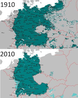
German Language Map1910vs 2010
Historical comparison maps showing the distribution of German-speaking populations in Central Europe in 1910 and 2010, with teal shading indicating German-speaking areas.
Bestenliste ansehen
Historical comparison maps showing the distribution of German-speaking populations in Central Europe in 1910 and 2010, with teal shading indicating German-speaking areas.
Bestenliste ansehenZieh die Teile aus dem Fach auf das Spielfeld. Bring eines nah an seinen Platz und es rastet automatisch ein.
Steckst du fest? Nutze einen Tipp, um ein Teil zu platzieren, oder wirf einen Blick auf die blasse Vorschau des fertigen Bildes.
Melde dich an, um Zeit, Züge und Sterne in deinem Profil zu speichern und in der Bestenliste aufzusteigen — komm dann zurück und schlage deine eigenen Rekorde.











