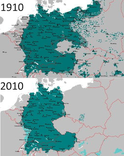
German Language Map1910vs 2010
Historical comparison maps showing the distribution of German-speaking populations in Central Europe in 1910 and 2010, with teal shading indicating German-speaking areas.
Voir le classement
Historical comparison maps showing the distribution of German-speaking populations in Central Europe in 1910 and 2010, with teal shading indicating German-speaking areas.
Voir le classementFaites glisser les pièces du plateau vers la grille. Approchez-en une de son emplacement et elle s'emboîte automatiquement.
Bloqué ? Utilisez un indice pour placer une pièce, ou jetez un œil à un aperçu estompé de l'image terminée.
Connectez-vous pour enregistrer votre temps, vos coups et vos étoiles dans votre profil et grimper au classement — puis revenez battre vos propres records.











